


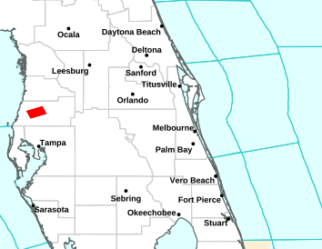


National Weather Service Forecast for: Orlando, Florida Forecast Details


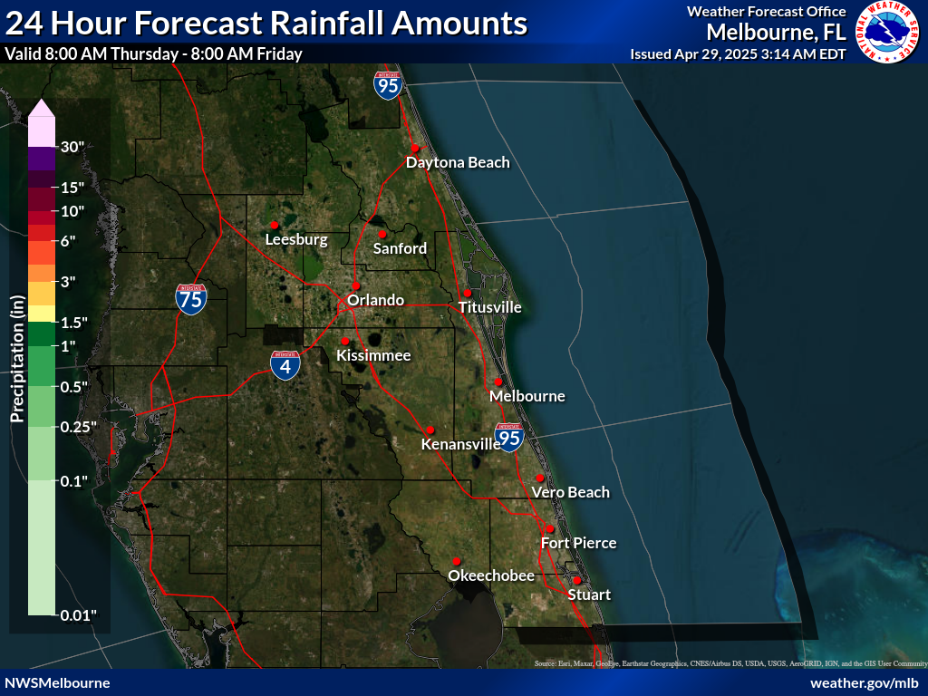
964
FXUS62 KMLB 110230
AFDMLB

Area Forecast Discussion
National Weather Service Melbourne FL
1030 PM EDT Tue Jun 10 2025

...New UPDATE...

.KEY MESSAGES...
Issued at 201 PM EDT Tue Jun 10 2025

- Hot and humid this week with peak heat indices up to 105

- Highest rain and storm chances shift farther west as flow
  becomes more onshore.

- A Moderate Risk for rip currents continues at area beaches

&&

.UPDATE...
Issued at 1019 PM EDT Tue Jun 10 2025

Pretty active weather this afternoon and evening, especially
along the sea breeze collision near the I-4 corridor. Storms were
pretty icy, producing excessive lightning at times, and sub-severe
hail in parts of Melbourne and Orlando. Multiple boundary
interactions in Orlando caused storms to become nearly stationary
for a bit, producing 3-5" of rainfall from Four Corners to Oak
Ridge, Winter Garden, and Pine Hills. Some debris showers linger
along and east of the I-4 corridor, but otherwise things have
quieted down. As far as the forecast goes, made some updates to
PoPs through the afternoon based on trends and updated guidance,
but otherwise no significant changes.

&&

.PREVIOUS DISCUSSION...
Issued at 201 PM EDT Tue Jun 10 2025

Rest of Today-Tonight...Showers and storms have developed along
the sea breeze as of around 230 PM. A storm near Melbourne was
reported to have produced sub-severe hail, so far. As the sea
breeze moves inland, this activity will continue to have the
ability to produce generally small hail (the 15Z XMR sounding
found 500mb temperatures around -7.5C, though melting can be
expected), as well as gusty winds to around 60 mph. The greatest
threat for strong to severe storms will be along the sea breeze
collision later this afternoon. Current CAM guidance suggests this
occurring near or just west of Orlando between 7-9 PM. Boundary
collisions will likely maintain showers and storms through around
10-11 PM, before drier conditions prevail the remainder of the
overnight hours. Hot conditions persist in areas that have yet to
see any rainfall yet today, though temperatures have cooled nicely
in the rain, with Melbourne currently at 76 degrees (its low for
the day). Overnight lows are forecast in the lower to mid-70s.

Wednesday-Monday...The Atlantic ridge axis will continue to lift
northward through late week, reaching the Georgia/South Carolina
area by the weekend. This will lead to prevailing southeasterly
flow across the local region and a dominant east coast sea breeze.
Thus, the highest coverage will move increasingly into the
interior/western half of the peninsula. Have maintained PoPs close
to the climatological average of 40-60%, rather than the
typically high NBM. Wednesday looks to be the best chance for
showers and storms, with up to 70% forecast west or Orlando.
Strong storms will remain a threat, with DCAPE values up to around
1000 J/kg potentially producing wind gusts up to around 50 mph.
By this weekend, building upper level ridging and another slug of
Saharan will likely limit PoPs, so the current forecast may be a
bit overzealous.

Late weekend into early next week, the ridge axis is forecast to
once again drift southward towards the local area. This would lead
to a return of southerly flow and a more centralized sea breeze
collision over the peninsula. Less coverage of showers and storms
would increase temperatures and heat indices, possibly close to
heat advisory criteria (108). For now, have maintained highs
upper 80s/lower 90s and peak heat indices up to 106F.

&&

.MARINE...
Issued at 201 PM EDT Tue Jun 10 2025

The Atlantic ridge axis will continue to drift well north of the
local area through late week. This will support southeast flow
into the weekend. Offshore-moving showers and storms today will
remain increasingly over the interior during this period, limiting
the amount of coverage during the afternoons, but increasing the
likelihood of overnight/early morning showers and storms over the
waters. By Sunday, the ridge axis is forecast to move southward
once again, veering prevailing flow southerly. Winds 15 kts or
less. Seas 2-3 ft.

&&

.AVIATION...
(00Z TAFs)
Issued at 646 PM EDT Tue Jun 10 2025

VFR conditions outside of convection. SCT-NUM nearly stationary
+TSRA developing across and around the Orlando Metro area from
boundary collisions. Expect this activity to propagate northeast
through 00Z-01Z, possibly making it to KDAB before diminishing
after 02Z. Quiet across the area after 04Z through Wednesday
morning, as becomes more S-SE. The sea breeze develops around
16Z-17Z, ushered inland faster than previous days by the more
onshore flow, with a collision near to west of KLEE. Highest
SHRA/TSRA chances west of the Orlando terminals, INVOF KLEE.

&&

.PRELIMINARY POINT TEMPS/POPS...
DAB  73  90  73  89 /  30  50  20  50
MCO  75  92  75  89 /  60  60  30  60
MLB  76  87  76  87 /  20  50  30  50
VRB  75  88  74  88 /  20  50  30  50
LEE  75  92  74  90 /  60  70  40  60
SFB  75  92  75  90 /  50  60  20  60
ORL  75  91  76  89 /  60  60  30  60
FPR  75  87  74  87 /  20  50  30  50

&&

.MLB WATCHES/WARNINGS/ADVISORIES...
FL...None.
AM...None.
&&

$$

UPDATE...Haley
AVIATION...Haley
National Weather Service Forecast for: Miami, Florida
Overnight Chance T-storms |
Wednesday Showers Likely then T-storms Likely |
Wednesday Night  Showers Likely |
Thursday Showers Likely then T-storms Likely |
Thursday Night T-storms Likely then Chance Showers |
| Lo 82 °F | Hi 85 °F | Lo 81 °F | Hi 86 °F | Lo 83 °F |
National Weather Service Forecast for: Miami, Florida Forecast Details


Contact © 2024, WeatherFL.com